


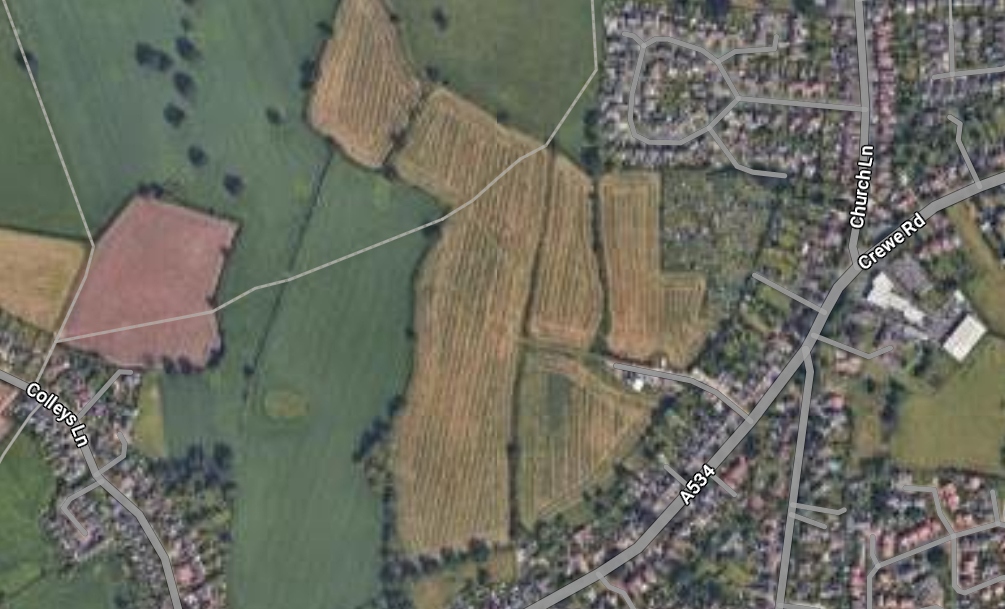
Redrow Homes is eyeing plans to build 220 houses on a 12.6 hectare site off Crewe Road in Wistaston.
The current site comprises open fields and grassland.
The developer has requested Cheshire East Council provides a formal screening opinion to confirm whether there is a requirement for an environmental impact assessment (EIA) in respect of the proposed scheme.
Environmental impact assessments consider the environmental effects of major development proposals and help councils decide whether to grant planning permission.
The letter submitted by SatPlan Planning and Development on behalf of the applicant, states: “Whilst the site is currently located within a strategic gap which covers an area of land between Crewe and Nantwich, it lies alongside the built edge and is well-related to the existing settlement of Wistaston, noting the site’s containment within Colleys Lane to the west.
“Consequently, the site is considered to represent a logical extension to the settlement.”
With the regard to the visual impact of the proposed scheme, the letter states: “Overall, the visual impact of the site is largely restricted to the immediate locality with primary visual receptors being passing footpath users in the north and private direct views afforded by residents whose properties share a boundary with the site along Crewe Road, Sandylands Park and, to a lesser extent, Colleys Lane.”
The proposed scheme will be for up to 220 houses and associated infrastructure.
The letter states: “Green infrastructure, to include public open space, would be located to the north of the PRoW (public right of way) connected via a new traffic-free pedestrian/cycle route through the centre of the site along the alignment of the existing watercourse.”
The proposed development would also include an access from Crewe Road.
The applicant’s agent argues the proposal does not constitute a scheme of more than local importance and ‘the types of impact anticipated are not of a level of magnitude, complexity or significance such that EIA would be required to evaluate them’.
(Story by Belinda Ryan, local democracy reporter)


I’m from Whitchurch and houses are getting put up all over I deliver round Crewe and surrounding areas they will need to rename it soon every where you go there is new houses going up absolutely crazy the traffic in another 3 years will not move maybe that’s the plan 15 mins towns and cities and you will not need a car.
Maybe CEC need the extra income from these new builds to recoup the £22K+ they spent on DISHWASHERS for CEC HQ – Unbelievable mismanagement of funds – aww maybe I am being harsh, as these councillor lovies shouldn’t wrinkle their hands. Cheaper to supply staff with rubber gloves.
://www.msn.com/en-gb/money/other/cash-strapped-cheshire-east-council-spends-22k-on-dishwashers-for-crewe-hq/ar-AA1Bd6fJ?ocid=msedgdhp&pc=U531&cvid=b6db42bb85724f95a29ce3fc5c7ce667&ei=59
I’m surprised the housing company isn’t willing to supply a play park as a kind of bribe to get their way, this is one of their usual things they offer.
Also planting trees,we cannot maintain the trees in the streets for a start.
Welcome to what one day could be the city of crewe or county of crewe!
The more farmland that gets built on the less food security the country has.
Crewe & Nantwich has a huge amount of empty buildings that can be converted into homes totaling more than 220 plus the massive area available next to the car park in crewe town centre.
Housing built on farmland when alternatives are available are only built to maximise profits per unit.
It would be interesting if it is approved what the Sect 106 Agreement covers and what is being planned for really affordable homes.
NIMBY brigade won’t this
It doesn’t matter if it’s linked to a local strategic plan, Labour have made it very clear they will actively ignore and over ride any local plans. Watch the green spaces disappear under this government.
What happened to the local area plan sealing a green gap between Crewe & Nantwich, the area is just becoming urban sprawl with village boundaries lost forever.
By the logic in this article, any field next to existing houses can form an extension for planning. Why isn’t this being linked to the local strategic plan? If it’s in there that’s fine, if not, it should be left as open space.